Welcome Pratacultural Science,Today is 2025-4-8 Tuesday!

| Citation: |
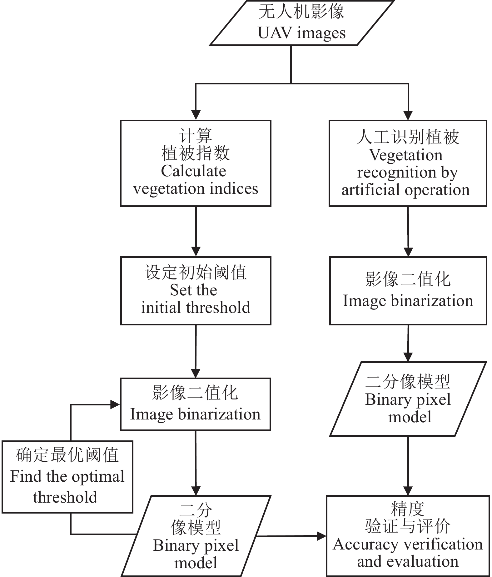
FU S, FENG Q S, DANG J Y, LEI K X, QIAO W X, LIANG T G, PAN D R, SUN B, JIANG J C. Comparison of grassland vegetation coverage extraction algorithms from UAV technology. Pratacultural Science, 2022, 39(3): 455-464
. DOI: 10.11829/j.issn.1001-0629.2021-0363

|
| [1] |
贾坤, 姚云军, 魏香琴, 高帅, 江波, 赵祥. 植被覆盖度遥感估算研究进展. 地球科学进展, 2013, 28(7): 774-782. doi: 10.11867/j.issn.1001-8166.2013.07.0774
JIA K, YAO Y J, WEI X Q, GAO S, JIANG B, ZHAO X. A review on fractional vegetation cover estimation using remote sensing. Advances in Earth Science, 2013, 28(7): 774-782. doi: 10.11867/j.issn.1001-8166.2013.07.0774
|
| [2] |
赵威成, 张红华, 马福义, 叶欣. 基于像元二分模型的地表植被覆盖度估算模块化设计与实现. 北京测绘, 2020, 34(3): 285-288.
ZHAO W C, ZHANG H H, MA F Y, YE X. Modular design and implementation of vegetation coverage estimation based on dimidiate pixel model. Beijing Surveying and Mapping, 2020, 34(3): 285-288.
|
| [3] |
葛静, 孟宝平, 杨淑霞, 高金龙, 冯琦胜, 梁天刚, 黄晓东, 高新华, 李文龙, 张仁平, 王云龙. 基于UAV技术和MODIS遥感数据的高寒草地盖度动态变化监测研究: 以黄河源东部地区为例. 草业学报, 2017, 26(3): 1-12.
GE J, MENG B P, YANG S X, GAO J L, FENG Q S, LIANG T G, HUANG X D, GAO X H, LI W L, ZHANG R P, WANG Y L. Dynamic monitoring of alpine grassland coverage based on UAV technology and MODIS remote sensing data: A case study in the headwaters of the Yellow River. Acta Prataculturae Sinica, 2017, 26(3): 1-12.
|
| [4] |
冯家莉, 刘凯, 朱远辉, 李勇, 柳林, 蒙琳. 无人机遥感在红树林资源调查中的应用. 热带地理, 2015, 35(1): 35-42.
FENG J L, LIU K, ZHU Y H, LI Y, LIU L, MENG L. Application of unmanned aerial vehicles to mangrove resources monitoring. Tropical Geography, 2015, 35(1): 35-42.
|
| [5] |
王光彦, 姚坚, 李登富, 赵培. 低空无人机遥感在水利工程测绘中的应用研究. 测绘与空间地理信息, 2016, 39(5): 113-115, 118.
WANG G Y, YAO J, LI D F, ZHAO P. Study on application of remote sensing by unmanned aerial vehicle in hydraulic engineering survey. Geomatics & Spatial Information Technology, 2016, 39(5): 113-115, 118.
|
| [6] |
纪景纯, 赵原, 邹晓娟, 宣可凡, 王伟鹏, 刘建立, 李晓鹏. 无人机遥感在农田信息监测中的应用进展. 土壤学报, 2019, 56(4): 773-784.
JI J C, ZHAO Y, ZOU X J, XUAN K F, WANG W P, LIU J L, LI X P. Advancement in application of UAV remote sensing to monitoring of farmlands. Acta Pedologica Sinica, 2019, 56(4): 773-784.
|
| [7] |
徐朋, 徐伟诚, 罗阳帆, 赵祚喜. 基于无人机可见光遥感影像的耕地精准分类方法研究. 中国农业科技导报, 2019, 21(6): 79-86.
XU P, XU W C, LUO Y F, ZHAO Z X. Precise classification of cultivated land based on visible remote sensing image of UAV. Journal of Agricultural Science and Technology, 2019, 21(6): 79-86.
|
| [8] |
丁雷龙, 李强子, 杜鑫, 田亦陈, 袁超. 基于无人机图像颜色指数的植被识别. 国土资源遥感, 2016, 28(1): 78-86.
DING L L, LI Q Z, DU X, TIAN Y C, YUAN C. Vegetation extraction method based on color indices from UAV images. Remote Sensing for Land and Resources, 2016, 28(1): 78-86.
|
| [9] |
刘艳慧, 蔡宗磊, 包妮沙, 刘善军. 基于无人机大样方草地植被覆盖度及生物量估算方法研究. 生态环境学报, 2018, 27(11): 2023-2032.
LIU Y H, CAI Z L, BAO N S, LIU S J. Research of grassland vegetation coverage and biomass estimation method based on major quadrat from UAV photogrammetry. Ecology and Environmental Sciences, 2018, 27(11): 2023-2032.
|
| [10] |
汪小钦, 王苗苗, 王绍强, 吴云东. 基于可见光波段无人机遥感的植被信息提取. 农业工程学报, 2015, 31(5): 152-159.
WANG X Q, WANG M M, WANG S Q, WU Y D. Extraction of vegetation information from visible unmanned aerial vehicle images. Transactions of the Chinese Society of Agricultural Engineering, 2015, 31(5): 152-159.
|
| [11] |
FRANCISCO G R, SINDHUJA S, JOE M M, WON S L, JESPER R, REZA E. Comparison of two aerial imaging platforms for identification of Huanglongbing-infected citrus trees. Computers and Electronics in Agriculture, 2013, 91: 106-115. doi: 10.1016/j.compag.2012.12.002
|
| [12] |
郭健. 基于植被指数和叶绿素荧光的总初级生产力估算. 北京测绘, 2019, 33(4): 427-432.
GUO J. Estimation of gross primary productivity based on vegetation index and chlirophyll fluorescence. Beijing Surveying and Mapping, 2019, 33(4): 427-432.
|
| [13] |
武红旗, 范燕敏, 靳瑰丽, 夏小伟. 伊犁绢蒿荒漠草地植物光谱特征. 草业科学, 2019, 36(7): 1765-1773.
WU H Q, FAN Y M, JIN G L, XIA X W. Spectral characteristics of main plant in Seriphidium transiliense desert grassland. Pratacultural Science, 2019, 36(7): 1765-1773.
|
| [14] |
冷若琳, 张瑶瑶, 谢健全, 李芙凝, 胥刚, 崔霞. 基于多光谱数据与小型无人机的甘南草地非生长季植被覆盖度. 草业科学, 2019, 36(11): 2742-2751.
LENG R L, ZHANG Y Y, XIE J Q, LI F N, XU G, CUI X. An analysis of fractional vegetation cover of the Gannan glasslan in the nongrowing season based on multispectral data and small UVAs. Pratacultural Science, 2019, 36(11): 2742-2751.
|
| [15] |
鲁军景, 孙雷刚, 黄文江. 作物病虫害遥感监测和预测预警研究进展. 遥感技术与应用, 2019, 34(1): 21-32.
LU J J, SUN L G, HUANG W J. Research progress in monitoring and forecasting of crop diseases and pests by remote sensing. Remote Sensing Technology and Application, 2019, 34(1): 21-32.
|
| [16] |
李鹏飞, 郭小平, 顾清敏, 张昕, 冯昶栋, 郭光. 基于可见光植被指数的乌海市矿山排土场坡面植被覆盖信息提取研究. 北京林业大学学报, 2020, 42(6): 102-112.
LI P F, GUO X P, GU Q M, ZHANG X, FENG C D, GUO G. Vegetation coverage information extraction of mine dump slope in Wuhai City of Inner Mongolia based on visible vegetation index. Journal of Beijing Forestry University, 2020, 42(6): 102-112.
|
| [17] |
徐大伟. 呼伦贝尔草原区不同草地类型分布变化及分析. 北京:中国农业科学院博士学位论文, 2019.
XU D W. Dynamic change and analysis of different grassland types distribution in the Hulunber grassland. PhD Thesis. Beijing: Chinese Academy of Agricultural Sciences, 2019.
|
| [18] |
HAGUE T, TILLETT N D, WHEELER H. Automated crop and weed monitoring in widely spaced cereals. Precision Agriculture, 2006, 7(1): 21-32. doi: 10.1007/s11119-005-6787-1
|
| [19] |
WOEBBECKE D M, MEYER G E, VON BARGEN K, MORTENSEN D A. Color indexes for weed identification under various soil, residue, and lighting condition. American Society of Agricultural Engineers Meeting, 1994, 38(1): 259-269.
|
| [20] |
CAMARGO N, JOAO. A combined Statistical-soft Computing Approach for Classification and Mapping Weed Species in Minimum-Tillage Systems. Lincoln: The University of Nebraska, 2004.
|
| [21] |
LOUHAICHI M, BORMAN M M, JOHNSON D E. Spatially located platform and aerial photography for documentation of grazing impacts on wheat. Geocarto International, 2001, 16(1): 65-70. doi: 10.1080/10106040108542184
|
| [22] |
KATAOKA T, KANEKO T, OKAMOTO H, HATA S. Crop growth estimation system using machine vision. Kobe: Proceedings 2003 IEEE / ASME International Conference on Advanced Intelligent Merchatronics, 2003.
|
| [23] |
GUIJARRO M, PAJARES G, RIOMOROS I, HERRERA P J, BURGOSARTIZZU X P, RIBEIRO A. Automatic segmentation of relevant textures in agricultural images. Computers and Electronics in Agriculture, 2011, 75(1): 75-83. doi: 10.1016/j.compag.2010.09.013
|
| [24] |
WOEBBECKE D M, MEYER G E, VONVARGEN K. Color indexes for weed identification under various soil, residue, and lighting conditions. Transactions of the American Society of Agricultural Engineers, 1995, 38: 259-269. doi: 10.13031/2013.27838
|
| [25] |
牛亚晓, 张立元, 韩文霆. 基于Lab颜色空间的棉花覆盖度提取方法. 农业机械学报, 2018, 49(10): 240-249.
NIU Y X, ZHANG L Y, HAN W T. Extraction methods of cotton coverage based on Lab color space. Transactions of the Chinese Society for Agricultural Machinery, 2018, 49(10): 240-249.
|
| [26] |
许高建, 沈杰, 徐浩宇. 基于Lab颜色空间下的小麦赤霉病图像分割. 中国农业大学学报, 2021, 26(10): 149-156.
XU G J, SHEN J, XU H J. Image segmentation of wheat scab based on Lab color space. Journal of China Agricultural University, 2021, 26(10): 149-156.
|
| [27] |
李苗苗. 植被覆盖度的遥感估算方法研究. 北京: 中国科学院研究生院硕士学位论文, 2003.
LI M M. The method of vegetation fraction estimation by remote sensing. Master Thesis. Beijing: Graduate School of Chinese Academy of Sciences, 2003.
|
| [28] |
周涛, 胡振琪, 韩佳政, 张浩. 基于无人机可见光影像的绿色植被提取. 中国环境科学, 2021, 41(5): 2380-2390.
ZHOU T, HU Z Q, HAN J Z, ZHANG H. Green vegetation extraction based on visible light image of UAV. China Environmental Science, 2021, 41(5): 2380-2390.
|
| [29] |
万炜, 肖生春, 陈小红, 滕泽宇, 丁爱军, 韩超, 颜长珍. 无人机遥感在野外植被盖度调查中的应用: 以阿拉善荒漠区灌木为例. 干旱区资源与环境, 2018, 32(9): 150-156.
WAN W, XIAO S C, CHEN X H, TENG Z Y, DING A J, HAN C, YAN C Z. Application of unmanned aerial vehicles to field vegetation coverage survey: A study of shrubs on Alxa desert. Journal of Arid Land Resources and Environment, 2018, 32(9): 150-156.
|
| [30] |
CHEN J J, ZHAO X N, ZHANG H Z, QIN Y, YI S H. Evaluation of the accuracy of the field quadrat survey of alpine grassland fractional vegetation cover based on the satellite remote sensing pixel scale. ISPRS International Journal of Geo-Information, 2019, 8(11): 497. doi: 10.3390/ijgi8110497
|
| [31] |
CHEN J J, YI S H, QIN Y, WANG X Y. Improving estimates of fractional vegetation cover based on UAV in alpine grassland on the Qinghai-Tibetan Plateau. Journal of Remote Sensing, 2016, 37(8): 1922-1936. doi: 10.1080/01431161.2016.1165884
|


 DownLoad: